
Drafted — not technically validated
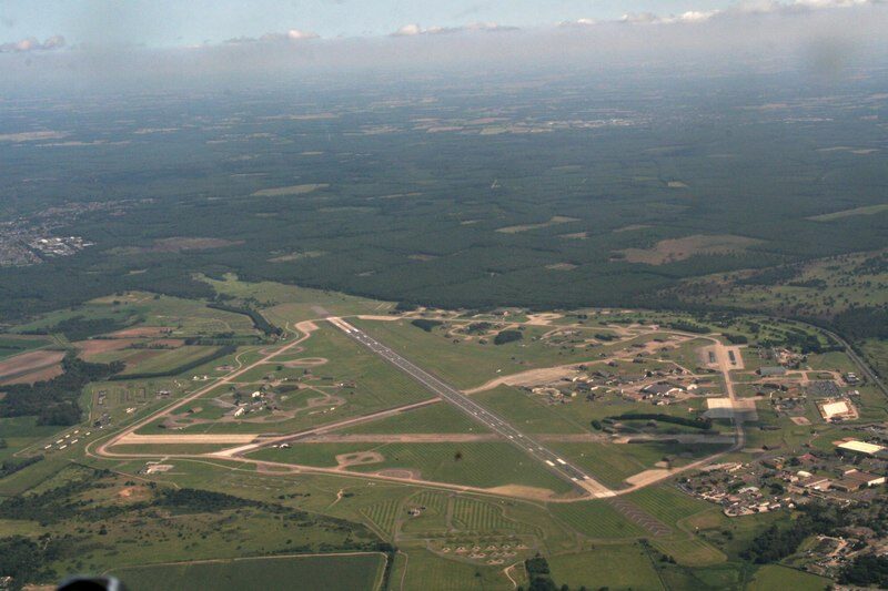
Record revision 1 · An RAF station in Suffolk that hosts only US units: the 48th Fighter Wing, with F-15Es and F-35As.
A real-world airfield as described in public sources, and how sim maps represent it. Units, facilities and names change; each is dated where the sources allow, and the charts are not for navigation. Use current official publications for flight planning.
Location and identity
Role and operators
- Status
- Active · Military
- Roles today
- Fighter and strike
Units
Permanently based units belong to the airfield; rotational and temporarily deployed units are there for a period or an operation. Dates are when the sources place each unit there; "as of" is when a source described it as current.
Current
48th Fighter Wing, the "Liberty Wing": the 492nd, 493rd, 494th and 495th Fighter Squadrons [1]
- Service
- United States, air force
- Basing
- Permanently based
- Aircraft
- F-15E Strike Eagle, F-35A Lightning II
- When
- as of Oct 2026
Earlier
48th Fighter Wing F-15C air-superiority squadrons [1]
- Service
- United States, air force
- Basing
- Permanently based
- Aircraft
- F-15C
- When
- until Apr 2022
48th Fighter Wing F-111F force, which flew the 1986 strike on Libya [1]
- Service
- United States, air force
- Basing
- Permanently based
- Aircraft
- F-111F
- When
- 1977–1992
Strategic Air Command B-29 bombers [1]
- Service
- United States, air force
- Basing
- Temporarily deployed
- Aircraft
- B-29
- When
- from Jul 1948, end not given
No. 149 Squadron RAF [1]
- Service
- United Kingdom, air force
- Basing
- Permanently based
- Aircraft
- Short Stirling
- When
- 6 Apr 1942 – 1944
Runways and facilities
The sources do not date these figures. Facilities not listed here are not documented in the sources cited, which does not mean the airfield lacks them.
- Arresting gear
- None documented in the sources cited
- Navaids
- None documented in the sources cited
Figure 1 — Runways at RAF Lakenheath (plan view, to scale)
Runways drawn to scale between their published threshold coordinates, true north up. Taxiways, aprons and buildings are not drawn. Threshold coordinates and width from OurAirports [2]; length from [1]. Not for navigation.
Sim maps
Represented in: no map checked so far
DCS: The Channel DCS World · Second World War
Confirmed absent · checked 2026-10-27 [3] [4]
The Channel map covers south-eastern England and north-eastern France [4]; its airfield list has no Lakenheath. [3]
Only the maps marked represented or confirmed absent have been checked. Any other map may or may not represent this airfield.
Other maps in Europe, not yet checked for this airfield, which may lie outside them: DCS: Kola, DCS: Cold War Germany, DCS: Normandy 2.0, Falcon BMS: Balkans, Falcon BMS: Hellenic, Falcon 4.0: Allied Force – Balkans.
Role today
Lakenheath is a Royal Air Force station that hosts only US Air Force units. [1] Its host is the 48th Fighter Wing, the “Liberty Wing”, of US Air Forces in Europe – Air Forces Africa, which flies the F-15E Strike EagleF-15E Strike Eagle AircraftThe two-seat, long-range, all-weather strike derivative of the Eagle. and, since December 2021, the F-35A Lightning II. [1]
History
The heath was a Royal Flying Corps bombing range in the First World War. [1] In 1940 the Air Ministry made Lakenheath a decoy for nearby RAF Mildenhall, and in 1941 it got surfaced runways and became a satellite of Mildenhall for Short Stirling bombers of No. 149 Squadron. [1] In 1944 the bombers left so the airfield could be rebuilt for very heavy bombers, and from July 1948 Strategic Air Command B-29s deployed there as the Cold War began. [1] In 1956 the CIA briefly formed its U-2 Detachment A at Lakenheath before moving it to Wiesbaden. [1]
The 48th arrived from France on 15 January 1960, flying F-100sF-100 Super Sabre AircraftThe first US Air Force fighter supersonic in level flight; a fighter-bomber and fast FAC in Vietnam., after President de Gaulle ordered nuclear-capable forces out of the country. [1] It flew F-4D Phantoms from the early 1970s and F-111Fs from 1977, and in April 1986 its F-111s flew the long-range strike on Libya, Operation El Dorado Canyon. [1] The F-15E replaced the F-111 from 1992, and F-15C air-superiority Eagles flew from Lakenheath until April 2022, ending 45 years of continuous USAF F-15 Eagle air-superiority operations in Europe. [1] In 2015 the Defense Department chose Lakenheath for 54 F-35As in two squadrons; the 495th Fighter Squadron reactivated as the first of them in October 2021. [1]
Sources
- RAF Lakenheath. Wikipedia (secondary source). https://en.wikipedia.org/wiki/RAF_Lakenheath (accessed 2026-10-27).
- Runway data, EGUL RAF Lakenheath. OurAirports open data (public domain, community-maintained). https://davidmegginson.github.io/ourairports-data/runways.csv (accessed 2026-10-27). Row for EGUL: threshold latitude and longitude, length and width.
- pydcs terrain data: The Channel airports (airports.py). pydcs, an open-source Python library for building DCS World missions, whose terrain data mirrors the game's. https://github.com/pydcs/dcs/blob/5ddcc63a2dcd661e16b14f7aa43219b93044855d/dcs/terrain/thechannel/airports.py (accessed 2026-10-27). The Channel map lists 12 airfields, eight in south-east England and four in France; Lakenheath is not among them.
- DCS: The Channel Map. Eagle Dynamics (product page). https://www.digitalcombatsimulator.com/en/shop/terrains/the_channel_terrain/ (accessed 2026-10-28).
- Airport data, EGUL. OurAirports open data (public domain, community-maintained). https://davidmegginson.github.io/ourairports-data/airports.csv (accessed 2026-10-28). Row for EGUL: latitude, longitude and identifiers.
Wikipedia articles are secondary sources and can change; they are cited with the date they were read. FAA airport data and diagrams are official but are reissued every 28 or 56 days; each is cited with the edition read. pydcs mirrors the DCS terrain data at the commit linked.