Drafted — not technically validated
Record revision 1 · The eastern Mediterranean from Cyprus to Damascus: Incirlik, Akrotiri, Khmeimim and Israeli bases, for modern and historical missions.
One simulator's map: what it covers, when it is set, and which airfields in this encyclopedia it represents. Sim maps change with updates; each claim is cited with the date it was read.
DCS: Syria
- Simulator
- DCS World
- Made by
- Ugra Media, for Eagle Dynamics
- Setting
- Present day: Present-day bases, but its makers say it supports missions from modern times to historical reenactments [1]
- Area
- About 1,000 × 900 km: much of Syria, all of Cyprus and Lebanon, and parts of Israel, Turkey, Jordan and Iraq, with enough of the eastern Mediterranean for carrier operations [1]
- Real-world theatre
- Middle East
- Purchase
- DCS WorldDCS: Syria Map by Ugra MediaDCS Store
Store pages checked 2026-10-28. Prices and availability change.
Map
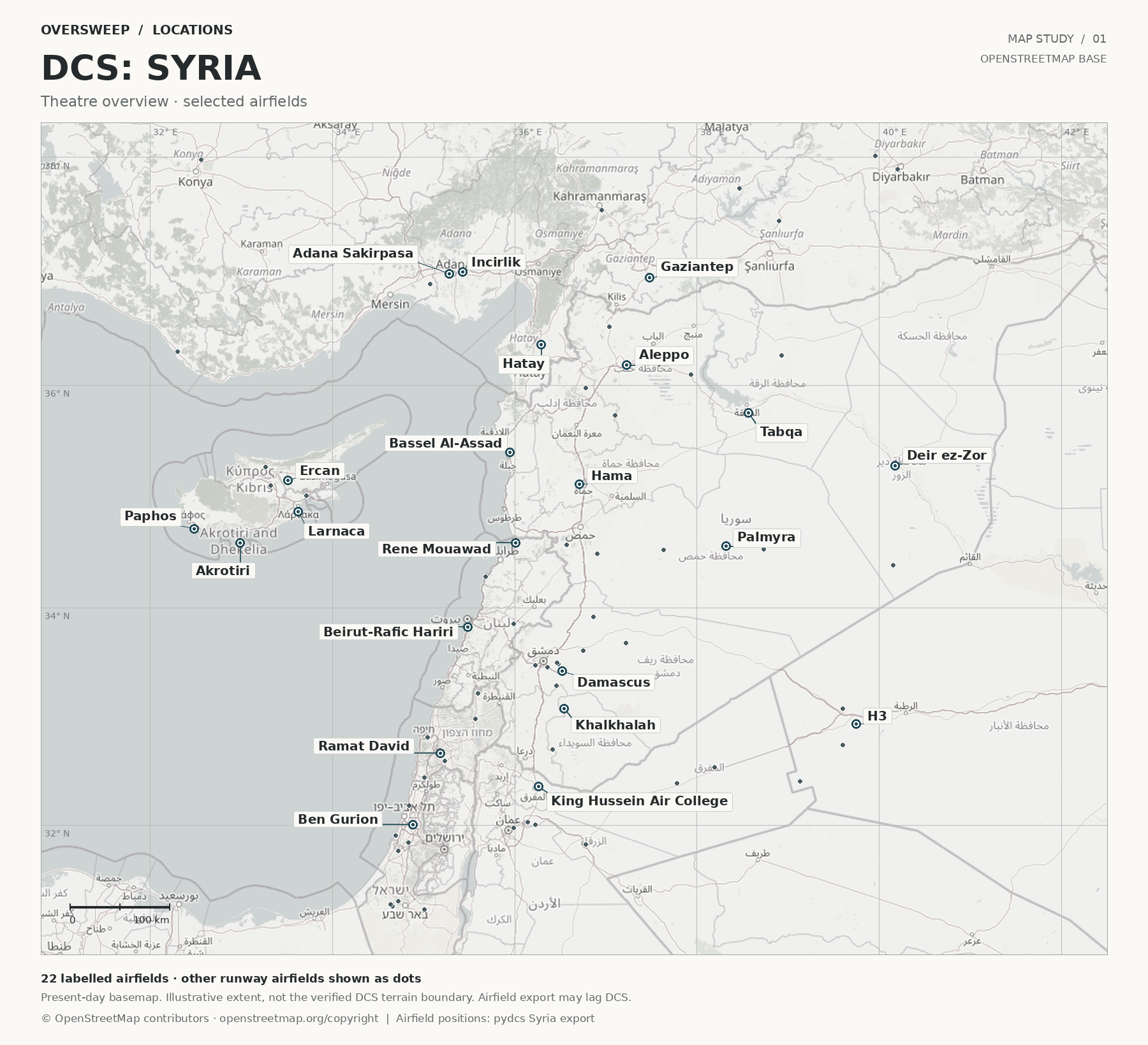
Explore the map or select an airfield. Markers show runway, radio and navigation data. Present-day OpenStreetMap geography; no exact simulator terrain boundary is shown. Airfield markers follow the simulator data, including on historical maps; the basemap does not depict their historical surroundings.
The interactive map is loading. The airfield reference table remains available below.
Airfield overlay: the same versioned simulator data as the table below. © OpenStreetMap contributors · ODbL.
Static overview
Airfields
Every airfield with a runway in Syria's data from the game: 80 airfields, plus 145 helipads and other landing sites listed below. Names link to this encyclopedia's entry where there is one.
| Airfield | Elevation | Runways | Tower (MHz) | TACAN, VOR and NDB | ILS |
|---|---|---|---|---|---|
| Abu al-Duhur35.7323° N, 37.1041° E | 820 ft | 27 (267°) / 09 (087°), 8,730 ft | VHF 122.2UHF 250.5low VHF 38.95 · HF 4.025 | — | — |
| Adana Sakirpasa36.9819° N, 35.2801° E | 56 ft | 23 (228°) / 05 (048°), 8,182 ft | VHF 121.1UHF 251.25low VHF 39.7 · HF 4.4 | NDB with marker 395 kHz (ADN)VOR-DME 112.7 MHz (ADA) | 05: 108.7 (IADA) |
| Adiyaman37.7313° N, 38.4689° E | 2,147 ft | 04 (043°) / 22 (223°), 6,373 ft | VHF 121.5UHF 243.0low VHF 41.85 · HF 5.0 | — | 04: 113.6 (KHD) |
| Akrotiri34.5904° N, 32.9878° E | 69 ft | 10 (102°) / 28 (282°), 8,276 ft | VHF 128.0UHF 252.0low VHF 40.45 · HF 4.775 | NDB 365 kHz (AK)TACAN 107X, 116.0 MHz (AKR) | 28: 109.7 (IAK) |
| Al Qusayr34.5693° N, 36.5715° E | 1,729 ft | 28 (275°) / 10 (095°), 8,585 ft | VHF 119.2UHF 251.8low VHF 40.25 · HF 4.675 | — | — |
| Al-Dumayr33.6097° N, 36.7491° E | 2,067 ft | 24 (239°) / 06 (059°), 9,546 ft | VHF 120.3UHF 253.35low VHF 41.8 · HF 4.85 | — | — |
| Aleppo36.1806° N, 37.2244° E | 1,254 ft | 27 (271°) / 09 (091°), 8,332 ft | VHF 119.1UHF 251.1low VHF 39.55 · HF 4.325 | NDB 396 kHz (ALE)NDB 365 kHz (MER)VOR-DME 114.5 MHz (ALE) | — |
| An Nasiriyah33.9186° N, 36.8658° E | 2,737 ft | 22 (218°) / 04 (038°), 8,172 ft | VHF 122.3UHF 252.3low VHF 40.75 · HF 4.925 | — | — |
| Bassel Al-Assad35.4038° N, 35.9502° E | 94 ft | 17L (171°) / 35R (351°), 6,568 ft17R (171°) / 35L (351°), 8,677 ft | VHF 118.1UHF 250.6low VHF 39.05 · HF 4.075 | DME 109.1 MHz (IBA)NDB 414 kHz (LTK)RSBN ch 7 (LTK)VOR-DME 114.8 MHz (LTK) | 17R: 109.1 (IBA)PRMG 35R: ch 9 (LTK) |
| Beirut-Rafic Hariri33.8251° N, 35.4830° E | 39 ft | 21 (208°) / 03 (028°), 6,620 ft34 (342°) / 16 (162°), 9,463 ft17 (172°) / 35 (352°), 7,116 ft | VHF 118.9UHF 253.2low VHF 41.65 · HF 4.325 | NDB with marker 351 kHz (BOD)VOR-DME 112.6 MHz (KAD) | 03: 110.7 (IKK)16: 109.5 (BIL)16: 110.1 (IBB) |
| Ben Gurion32.0061° N, 34.8824° E | 91 ft | 21 (204°) / 03 (024°), 8,846 ft26 (255°) / 08 (075°), 9,754 ft12 (117°) / 30 (297°), 8,491 ft | VHF 134.6UHF 250.7low VHF 39.15 · HF 4.125 | VOR-DME 113.5 MHz (BGN) | 08: 110.9 (BA)12: 110.3 (BG)21: 109.7 (BN)26: 108.7 (BA)30: 111.9 (BD) |
| Chukurova36.8927° N, 35.0693° E | 10 ft | 21R (206°) / 03L (026°), 11,215 ft21L (206°) / 03R (026°), 11,210 ft | VHF 120.8UHF 245.0low VHF 38.4 · HF 4.25 | NDB 320.0 MHz (CKR)VOR-DME 113.7 MHz (CKR) | 03R: 329.75 (ICKU)21L: 333.95 (ICKR) |
| Damascus33.4255° N, 36.5185° E | 2,008 ft | 05L (043°) / 23R (223°), 11,424 ft05R (043°) / 23L (223°), 11,295 ft | VHF 118.5UHF 253.25low VHF 41.7 · HF 4.9 | NDB 264 kHz (ABD)NDB 342 kHz (DAL)VOR-DME 116.0 MHz (DAM) | 05R: 111.1 (DAML)23R: 109.9 (IDA) |
| Deir ez-Zor35.2854° N, 40.1761° E | 694 ft | 10 (104°) / 28 (285°), 9,339 ft | VHF 118.1UHF 251.95low VHF 40.4 · HF 4.75 | NDB 295 kHz (DRZ)VOR-DME 117.0 MHz (DRZ) | — |
| Diyarbakir37.8933° N, 40.1987° E | 2,211 ft | 34R (337°) / 16L (157°), 11,430 ft34L (337°) / 16R (157°), 11,434 ft | VHF 132.4UHF 225.0low VHF 38.9 · HF 3.8 | NDB 330 kHz (DYB)TACAN 37X, 110.0 MHz (DIY) | 16L: 109.4 (IDD)34R: 109.2 (IDI) |
| Ercan35.1496° N, 33.5125° E | 380 ft | 11 (106°) / 29 (286°), 9,365 ft | VHF 120.2UHF 252.25low VHF 40.7 · HF 4.9 | VOR-DME 117.0 MHz (ECN) | 29: 108.3 (IECR) |
| Eyn Shemer32.4409° N, 35.0070° E | 101 ft | 09 (093°) / 27 (273°), 4,826 ft | VHF 123.4UHF 250.05low VHF 38.45 · HF 3.775 | — | — |
| Gaziantep36.9481° N, 37.4783° E | 2,237 ft | 10 (099°) / 28 (279°), 9,495 ft | VHF 120.1UHF 250.1low VHF 38.5 · HF 3.8 | NDB 432 kHz (GAZ)VOR-DME 116.7 MHz (GAZ) | 28: 109.1 (IGNP) |
| Gazipasa36.2989° N, 32.2976° E | 79 ft | 08 (076°) / 26 (256°), 6,885 ft | VHF 119.25UHF 251.9low VHF 40.35 · HF 4.725 | NDB 316 kHz (GZP)VOR-DME 89X, 114.2 MHz (GZP) | 08: 108.5 (IGZP) |
| Gecitkale35.2360° N, 33.7209° E | 148 ft | 09 (085°) / 27 (265°), 8,156 ft | VHF 120.0UHF 252.35low VHF 40.8 · HF 4.95 | NDB 435 kHz (GKE)VOR-DME 114.3 MHz (GKE) | — |
| Gulechoba38.0120° N, 39.9547° E | 2,546 ft | 01 (006°) / 19 (186°), 4,483 ft | — | — | — |
| H332.9362° N, 39.7458° E | 2,549 ft | 06 (060°) / 24 (240°), 7,931 ft11 (107°) / 29 (287°), 8,832 ft | VHF 122.0UHF 252.5low VHF 40.95 · HF 4.725 | — | — |
| H3 Northwest33.0760° N, 39.5966° E | 2,576 ft | 30 (297°) / 12 (117°), 7,377 ft | VHF 122.1UHF 252.55low VHF 41.0 · HF 4.825 | — | — |
| H3 Southwest32.7433° N, 39.6024° E | 2,671 ft | 30 (296°) / 12 (116°), 7,073 ft | VHF 122.4UHF 252.6low VHF 41.05 · HF 4.775 | — | — |
| H432.5393° N, 38.1951° E | 2,257 ft | 28 (278°) / 10 (098°), 7,179 ft | VHF 122.6UHF 250.15low VHF 38.55 · HF 3.825 | — | — |
| H4 Emergency32.3863° N, 37.7817° E | 2,502 ft | 10 (085°) / 28 (265°), 4,069 ft | VHF 118.5UHF 250.0low VHF 40.0 · HF 4.5 | — | — |
| Haifa32.8107° N, 35.0435° E | 20 ft | 34 (335°) / 16 (155°), 3,253 ft | VHF 127.8UHF 250.2low VHF 38.6 · HF 3.85 | — | — |
| Hama35.1180° N, 36.7124° E | 984 ft | 27 (273°) / 09 (093°), 7,958 ft | VHF 118.05UHF 250.25low VHF 38.65 · HF 3.875 | — | — |
| Hatay36.3623° N, 36.2874° E | 228 ft | 22 (217°) / 04 (037°), 9,053 ft | VHF 128.5UHF 250.3low VHF 38.7 · HF 3.9 | NDB 336 kHz (HTY)VOR-DME 112.05 MHz (HTY) | 04: 108.9 (IHAT) |
| Hatzerim31.2388° N, 34.6577° E | 708 ft | 10L (100°) / 28R (280°), 6,922 ft10R (100°) / 28L (280°), 6,846 ft | VHF 128.2UHF 259.0low VHF 41.95 · HF 4.975 | VORTAC 96X, 114.9 MHz (BRA) | — |
| Hatzor31.7604° N, 34.7253° E | 110 ft | 23 (229°) / 05 (049°), 7,518 ft29R (287°) / 11L (107°), 7,037 ft11R (107°) / 29L (287°), 7,495 ft | VHF 125.75UHF 250.75low VHF 39.2 · HF 4.15 | VORTAC 106X, 115.9 MHz (HZR) | 05: 108.5 (HZR) |
| Herzliya32.1794° N, 34.8379° E | 118 ft | 28 (284°) / 10 (104°), 4,114 ft | VHF 122.2UHF 253.05low VHF 41.5 · HF 4.6 | — | — |
| Incirlik37.0020° N, 35.4261° E | 191 ft | 05 (047°) / 23 (227°), 9,663 ft | VHF 122.1UHF 360.1low VHF 38.75 · HF 3.925 | TACAN 21X* (DAN) | 05: 109.3 (IDAN)23: 111.7 (IDNA) |
| Jirah36.0969° N, 37.9365° E | 1,158 ft | 10 (095°) / 28 (275°), 9,414 ft | VHF 118.1UHF 250.35low VHF 38.8 · HF 3.95 | — | — |
| Kahramanmaras37.5385° N, 36.9524° E | 1,569 ft | 25 (249°) / 07 (069°), 5,932 ft | VHF 118.75UHF 225.0low VHF 38.4 · HF 3.75 | — | — |
| Kedem31.2605° N, 34.6405° E | 639 ft | 10 (100°) / 28 (280°), 4,782 ft | VHF 119.0UHF 256.0low VHF 41.9 · HF 3.75 | — | — |
| Khalkhalah33.0784° N, 36.5411° E | 2,323 ft | 07 (070°) / 25 (250°), 7,920 ft15 (145°) / 33 (325°), 8,248 ft | VHF 122.5UHF 250.4low VHF 38.85 · HF 3.975 | — | — |
| King Abdullah II32.0055° N, 36.2237° E | 2,297 ft | 31 (305°) / 13 (125°), 7,044 ft | VHF 118.4UHF 253.0low VHF 41.45 · HF 3.9 | — | 31: 109.1 |
| King Hussein Air College32.3567° N, 36.2599° E | 2,205 ft | 31 (306°) / 13 (126°), 8,595 ft | VHF 118.3UHF 250.45low VHF 38.9 · HF 4.0 | — | — |
| Kingsfield35.0148° N, 33.7170° E | 276 ft | 24 (235°) / 06 (055°), 3,069 ft | VHF 121.0UHF 252.05low VHF 40.5 · HF 4.8 | — | — |
| Kiryat Shmona33.2158° N, 35.5958° E | 341 ft | 03 (031°) / 21 (211°), 3,259 ft | VHF 118.4UHF 250.55low VHF 39.0 · HF 4.05 | — | — |
| Konya37.9777° N, 32.5615° E | 3,407 ft | 01L (011°) / 19R (191°), 9,600 ft01R (011°) / 19L (191°), 9,598 ft | VHF 132.4UHF 225.0low VHF 38.9 · HF 3.8 | DME 26X, 108.9 MHz (IKNY)NDB 390 kHz (KNY)TACAN 88X, 114.1 MHz (KON)VOR-DME 49X, 111.2 MHz (KNY) | runway not given: 108.9 (IKNY) |
| Kuweires36.1875° N, 37.5815° E | 1,186 ft | 10 (095°) / 28 (275°), 6,663 ft | VHF 120.5UHF 251.35low VHF 39.8 · HF 4.45 | — | — |
| Lakatamia35.1046° N, 33.3217° E | 758 ft | 17 (166°) / 35 (346°), 1,230 ft | VHF 120.2UHF 252.2low VHF 40.65 · HF 4.875 | — | — |
| Larnaca34.8732° N, 33.6232° E | 16 ft | 04 (040°) / 22 (220°), 8,009 ft | VHF 121.2UHF 252.15low VHF 40.6 · HF 4.85 | NDB 432 kHz (LCA)VOR-DME 112.8 MHz (LCA) | 22: 110.3 (ILC) |
| Marj as Sultan North33.5003° N, 36.4671° E | 2,007 ft | 08 (074°) / 26 (254°), 476 ft | VHF 122.7UHF 250.85low VHF 39.3 · HF 4.2 | — | — |
| Marj as Sultan South33.4872° N, 36.4754° E | 2,006 ft | 09 (084°) / 27 (264°), 559 ft | VHF 122.9UHF 253.3low VHF 41.75 · HF 4.95 | — | — |
| Marj Ruhayyil33.2888° N, 36.4554° E | 2,161 ft | 06L (057°) / 24R (237°), 7,577 ft | VHF 120.8UHF 250.9low VHF 39.35 · HF 4.225 | — | — |
| Marka31.9728° N, 35.9917° E | 2,493 ft | 24 (239°) / 06 (059°), 10,422 ft | VHF 118.1UHF 253.1low VHF 41.55 · HF 3.95 | — | 24: 109.5 (IAMN) |
| Megiddo32.5971° N, 35.2301° E | 180 ft | 09 (086°) / 27 (266°), 6,098 ft | VHF 119.9UHF 250.95low VHF 39.4 · HF 4.25 | — | — |
| Mezzeh33.4778° N, 36.2242° E | 2,363 ft | 24 (235°) / 06 (055°), 7,522 ft | VHF 120.7UHF 251.0low VHF 39.45 · HF 4.275 | NDB 358 kHz (MEZ) | — |
| Minakh36.5214° N, 37.0413° E | 1,614 ft | 04 (035°) / 22 (215°), 3,073 ft10 (095°) / 28 (275°), 4,649 ft | VHF 120.6UHF 251.05low VHF 39.5 · HF 4.3 | — | — |
| Muwaffaq Salti31.8176° N, 36.7787° E | 1,636 ft | 26 (255°) / 08 (075°), 7,598 ft31 (306°) / 13 (126°), 8,692 ft | VHF 120.5UHF 253.15low VHF 41.6 · HF 4.45 | — | 26: 109.7 (IGHS)31: 108.9 (IGHI) |
| Nevatim31.2084° N, 35.0121° E | 1,378 ft | 25 (252°) / 07 (072°), 12,212 ft26R (252°) / 08L (072°), 8,237 ft26L (252°) / 08R (072°), 10,764 ft | VHF 132.4UHF 225.0low VHF 38.9 · HF 3.8 | VOR-DME 114.3 MHz (BSA)VOR-DME 111.5 MHz (NGV) | 07: 111.5 (GR)08L: 108.3 (GR) |
| Nicosia35.1527° N, 33.2751° E | 689 ft | 09 (083°) / 27 (263°), 5,498 ft32 (320°) / 14 (140°), 7,721 ft | — | — | — |
| Palmachim31.9028° N, 34.6934° E | 45 ft | 03L (020°) / 21R (200°), 3,996 ft03R (020°) / 21L (200°), 6,426 ft | VHF 118.25UHF 250.8low VHF 39.25 · HF 4.175 | — | — |
| Palmyra34.5573° N, 38.3168° E | 1,292 ft | 26 (259°) / 08 (079°), 9,093 ft | VHF 121.9UHF 251.15low VHF 39.6 · HF 4.35 | NDB 337 kHz (PAL)NDB 363 kHz (PLR) | — |
| Paphos34.7182° N, 32.4848° E | 85 ft | 11 (105°) / 29 (285°), 8,425 ft | VHF 119.9UHF 252.1low VHF 40.55 · HF 4.825 | DME 108.9 MHz (IPA)NDB 328 kHz (PHA)TACAN 79X* (PHA)VOR-DME 117.9 MHz (PHA) | 29: 108.9 (IPA) |
| Pinarbashi35.2738° N, 33.2682° E | 771 ft | 16 (159°) / 34 (339°), 3,365 ft | VHF 121.0UHF 252.4low VHF 40.85 · HF 4.75 | — | — |
| Prince Hassan32.1607° N, 37.1494° E | 2,165 ft | 13 (126°) / 31 (306°), 9,314 ft | VHF 122.6UHF 252.95low VHF 41.4 · HF 4.3 | VORTAC 106X, 115.9 MHz (ABC) | 31: 111.7 (ABC) |
| Qabr as Sitt33.4587° N, 36.3577° E | 2,134 ft | 05 (052°) / 23 (232°), 497 ft | VHF 122.6UHF 251.2low VHF 39.65 · HF 4.375 | — | — |
| Ramat David32.6664° N, 35.1842° E | 130 ft | 09 (082°) / 27 (262°), 7,443 ft11 (103°) / 29 (283°), 7,533 ft33 (320°) / 15 (140°), 7,613 ft | VHF 118.6UHF 251.3low VHF 39.75 · HF 4.425 | NDB 368 kHz (RMD)VORTAC 84X, 113.7 MHz (RMD) | 33: 111.1 (RMD) |
| Rayak33.8511° N, 35.9873° E | 2,976 ft | 04 (040°) / 22 (220°), 8,699 ft | VHF 124.4UHF 251.4low VHF 39.85 · HF 4.475 | — | — |
| Rene Mouawad34.5893° N, 36.0114° E | 16 ft | 06 (056°) / 24 (236°), 8,615 ft | VHF 121.0UHF 251.45low VHF 39.9 · HF 4.5 | — | — |
| Rosh Pina32.9826° N, 35.5707° E | 868 ft | 33 (325°) / 15 (145°), 2,711 ft | VHF 118.45UHF 251.5low VHF 39.95 · HF 4.525 | VOR-DME 115.3 MHz (ROP) | — |
| Ruwayshid32.4050° N, 39.1305° E | 2,977 ft | 27 (271°) / 09 (091°), 7,274 ft | VHF 122.1UHF 252.65low VHF 41.1 · HF 4.4 | — | — |
| Sanliurfa37.4481° N, 38.8984° E | 2,703 ft | 22 (216°) / 04 (036°), 12,321 ft | VHF 118.4UHF 252.7low VHF 41.15 · HF 4.15 | NDB 391 kHz (GAP)VOR-DME 79X, 113.2 MHz (GAP) | 04: 111.9 (ISUR) |
| Sayqal33.6798° N, 37.2171° E | 2,274 ft | 08 (084°) / 26 (265°), 7,935 ft | VHF 120.4UHF 251.55low VHF 40.0 · HF 4.55 | — | — |
| Shayrat34.4902° N, 36.9076° E | 2,638 ft | 11 (106°) / 29 (286°), 8,553 ft | VHF 120.2UHF 251.6low VHF 40.05 · HF 4.575 | — | — |
| T234.3898° N, 40.1535° E | 1,283 ft | 04 (035°) / 22 (215°), 3,492 ft31 (305°) / 13 (125°), 3,436 ft | VHF 123.5UHF 255.0low VHF 42.0 · HF 3.85 | — | — |
| T334.5290° N, 38.7294° E | 1,274 ft | 28 (277°) / 10 (097°), 6,068 ft | VHF 119.25UHF 251.9low VHF 40.35 · HF 4.725 | — | — |
| Tabqa35.7547° N, 38.5664° E | 1,099 ft | 09 (087°) / 27 (267°), 9,036 ft | VHF 118.5UHF 251.65low VHF 40.1 · HF 4.6 | — | — |
| Taftanaz35.9741° N, 36.7814° E | 1,020 ft | 28 (274°) / 10 (094°), 2,705 ft | VHF 122.8UHF 251.7low VHF 40.15 · HF 4.625 | — | — |
| Tal Siman36.2624° N, 38.9283° E | 981 ft | 10 (097°) / 28 (277°), 2,616 ft | VHF 121.9UHF 252.85low VHF 41.3 · HF 4.1 | — | — |
| Tel Nof31.8384° N, 34.8326° E | 180 ft | 33R (326°) / 15L (146°), 7,107 ft33L (326°) / 15R (146°), 7,114 ft18 (178°) / 36 (358°), 7,338 ft | VHF 128.1UHF 250.65low VHF 39.1 · HF 4.1 | TACAN 87X* (AKR) | 36: 109.1 (AKR) |
| Teyman31.2870° N, 34.7228° E | 574 ft | 32 (312°) / 14 (132°), 3,132 ft | VHF 123.5UHF 255.0low VHF 42.0 · HF 3.85 | VOR-DME 114.3 MHz (BSA) | — |
| Tha'lah32.7040° N, 36.4138° E | 2,405 ft | 05R (051°) / 23L (231°), 8,025 ft | VHF 118.0UHF 252.8low VHF 41.25 · HF 3.925 | — | — |
| Tiyas34.5226° N, 37.6301° E | 1,798 ft | 09 (084°) / 27 (264°), 9,420 ft | VHF 120.5UHF 251.75low VHF 40.2 · HF 4.65 | — | — |
| Wujah Al Hajar34.2813° N, 35.6801° E | 650 ft | 20 (202°) / 02 (022°), 4,717 ft | VHF 120.5UHF 251.85low VHF 40.3 · HF 4.7 | VOR-DME 116.2 MHz (CAK) | — |
| Zarqa32.0258° N, 36.1437° E | 2,135 ft | 10 (101°) / 28 (281°), 5,933 ft | VHF 119.9UHF 252.1low VHF 40.55 · HF 4.825 | — | — |
145 helipads and other landing sites without a runway
At Tanf · H_med_orig_01 · H_med_orig_02 · H_med_orig_03 · H_med_orig_04 · H_med_orig_05 · H_med_orig_06 · H_med_orig_07 · H_med_orig_08 · H_med_orig_09 · HC01 · HC02 · HC03 · HC04 · HC05 · HC06 · HI01 · HI02 · HI03 · HI05 · HI06 · HI07 · HI08 · HI09 · HI11 · HI12 · HI13 · HI14 · HI15 · HI16 · HI17 · HI18 · HI20 · HI21 · HI22 · HI23 · HI24 · HI25 · HI26 · HJ01 · HJ02 · HJ03 · HJ04 · HL01 · HL02 · HL03 · HL04 · HL05 · HL06 · HL07 · HL08 · HL09 · HL10 · HL11 · HL12 · HL13 · HMed00 · HMed01 · HMed02 · HMed03 · HMed04 · HMed05 · HMed06 · HMed07 · HMed08 · HMed09 · HMed10 · HMed11 · HMed12 · HMed13 · HMed14 · HMed15 · HMed16 · HMed17 · HMed18 · HMed19 · HMed20 · HMed21 · HMed22 · HMed23 · HMed24 · HMed25 · HMed26 · HMed27 · HMed28 · HMed29 · HMed30 · HOil01 · HOil02 · HOil03 · HOil04 · HOil05 · HOil06 · HS02 · HS03 · HS04 · HS05 · HS06 · HS07 · HS08 · HS09 · HS10 · HS11 · HS12 · HS13 · HS14 · HS15 · HS16 · HS17 · HS18 · HS19 · HS20 · HS21 · HS22 · HS23 · HS24 · HS25 · HS26 · HS27 · HS28 · HS29 · HS30 · HS31 · HS32 · HS33 · HS34 · HS35 · HS36 · HS37 · HS38 · HS39 · HS40 · HS41 · HS42 · HStad01 · HStad02 · HStad03 · HStad04 · HStad05 · HStad06 · HT01 · HT02 · Kharab Ishk · Naqoura · Sanliurfa Heliport
Source: dcs-world-schema reference data: Syria airbases, beacons and navaids, dcs-world-schema, open-source data extracted by running DCS World 2.9.30.28536 (extracted 2026-10-04), at commit c3091e6. † Where that data gives an airfield no tower radio, the frequencies come from pydcs terrain data: syria airports (airports.py), an open-source library whose terrain data mirrors the game's. Runway headings are magnetic, as the game computes them; lengths and elevations are converted from metres. The game gives TACAN and DME channels no X or Y band. Where a beacon’s listed frequency is the reply or paired VHF frequency of one band (ICAO Annex 10 channel plan), that band is shown. * marks an assumed X: the game lists no frequency that settles it, and every ground TACAN whose frequency does settle it is X. A dash means the game gives none.
Airfield coverage
| Airfield | On this map | Name in the sim | Checked |
|---|---|---|---|
| Incirlik Air Base | Represented | Incirlik | 2026-10-27 |
| RAF Akrotiri | Represented | Akrotiri | 2026-10-27 |
| Ramat David Airbase | Represented | Ramat David | 2026-10-28 |
| Khmeimim Air Base | Represented; 1 known difference | Bassel Al-Assad | 2026-10-28 |
| Damascus International Airport | Represented | Damascus | 2026-10-28 |
| Aleppo International Airport | Represented | Aleppo | 2026-10-28 |
| Abu al-Duhur Air Base | Represented; 1 known difference | Abu al-Duhur | 2026-10-28 |
| Hama Air Base | Represented | Hama | 2026-10-28 |
| Taftanaz Air Base | Represented | Taftanaz | 2026-10-28 |
| Jirah Air Base | Represented | Jirah | 2026-10-28 |
| Tabqa Air Base | Represented | Tabqa | 2026-10-28 |
| Palmyra Airport | Represented | Palmyra | 2026-10-28 |
| Tiyas Air Base | Represented | Tiyas | 2026-10-28 |
| Beirut–Rafic Hariri International Airport | Represented | Beirut-Rafic Hariri | 2026-10-28 |
Each airfield's page cites the sources for its entry. Airfields not listed have not been checked against this map.
Other differences from reality
Coverage
The map covers most of the eastern Mediterranean, with about 69 airfields and heliports, including the large international airports of Damascus, Beirut, Tel Aviv and Larnaca, military bases such as Incirlik, RAF Akrotiri, Russia’s Khmeimim and Israel’s Ramat David, and more than 100 military bases and checkpoints. [1] It is built around present-day bases, such as Khmeimim and the US helicopter base at Harab-Ishq, but its makers say it supports missions from modern times to historical reenactments. [1] Each airfield’s radios, runways and runway beacons are in the game’s terrain data. [3]
Sources
- DCS: Syria Map. Eagle Dynamics and Ugra Media (product page). https://www.digitalcombatsimulator.com/en/shop/terrains/syria_terrain/ (accessed 2026-10-27).
- Operation Inherent Resolve. Wikipedia (secondary source). https://en.wikipedia.org/wiki/Operation_Inherent_Resolve (accessed 2026-10-27).
- pydcs terrain data: Syria airports (airports.py). pydcs, an open-source Python library for building DCS World missions, whose terrain data mirrors the game's. https://github.com/pydcs/dcs/blob/5ddcc63a2dcd661e16b14f7aa43219b93044855d/dcs/terrain/syria/airports.py (accessed 2026-10-27).
Wikipedia articles are secondary sources and can change; they are cited with the date they were read. Vendor pages describe the current release of each map.