
Drafted — not technically validated
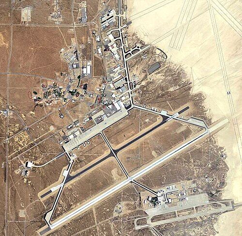
Record revision 1 · The Air Force's flight test centre beside Rogers Dry Lake, where the X-1 broke the sound barrier and the Space Shuttle first landed.
A real-world airfield as described in public sources, and how sim maps represent it. Units, facilities and names change; each is dated where the sources allow, and the charts are not for navigation. Use current official publications for flight planning.
Location and identity
- Country or territory
- United States
- Coordinates
- 34.9108° N, 117.8864° W [6]
- Elevation
- 2,311 ft (704 m) [2]
- Identifiers
- ICAO KEDW · IATA EDW · FAA EDW
- Other names
- Muroc (former name, until Dec 1949) [1]
- Opened
- 1933, as the Muroc bombing and gunnery range; named Edwards Air Force Base in December 1949 [1]
- Theatre
- North America
Role and operators
- Status
- Active · Military
- Roles today
- Flight test
- Operators
- US Air Force, Air Force Materiel Command · United States, air force · current; start date not given [1]
Units
Permanently based units belong to the airfield; rotational and temporarily deployed units are there for a period or an operation. Dates are when the sources place each unit there; "as of" is when a source described it as current.
Current
Air Force Test Center and its 412th Test Wing, which runs the base and flies the Air Force's test aircraft [1]
- Service
- United States, air force
- Basing
- Permanently based
- When
- as of Oct 2026
US Air Force Test Pilot School [1]
- Service
- United States, air force
- Basing
- Permanently based
- When
- as of Oct 2026
NASA Armstrong Flight Research Center [1]
- Service
- United States, government (non-military)
- Basing
- Permanently based
- When
- as of Oct 2026
Runways and facilities
From data effective Oct 2026. Facilities not listed here are not documented in the sources cited, which does not mean the airfield lacks them.
| Runway | Length | Width | Surface |
|---|---|---|---|
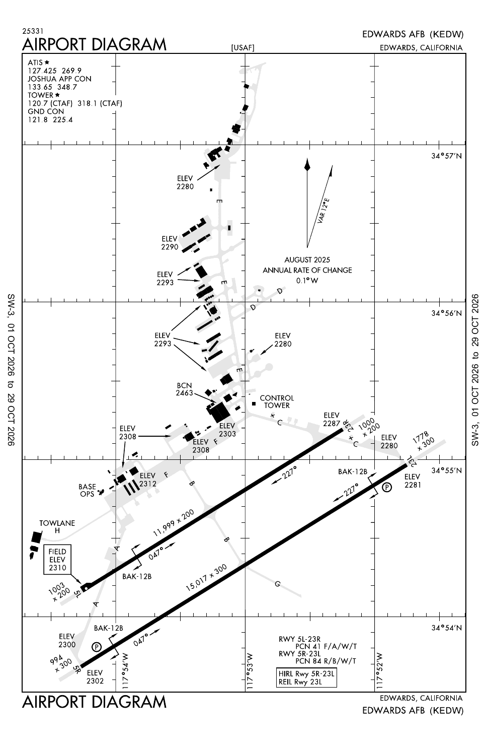
| 05R/23L [2] | 15,024 ft (4,579 m) | 300 ft (91 m) | concrete |
| 05L/23R [2] | 12,000 ft (3,658 m) | 200 ft (61 m) | asphalt |
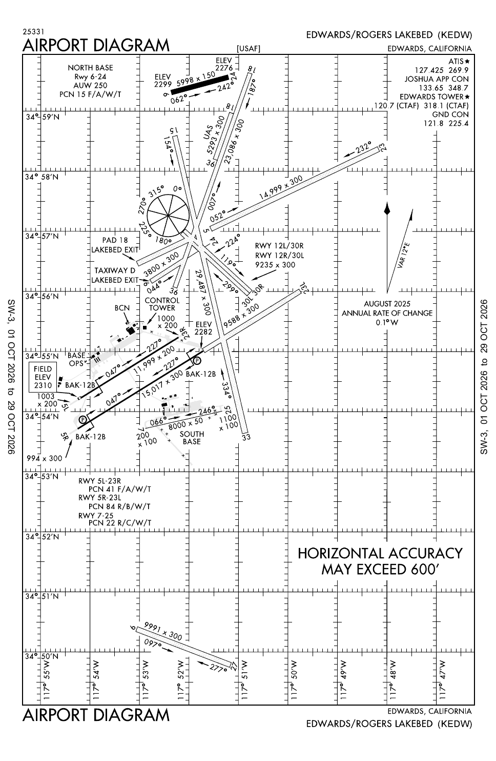
| South Base 07/25 [2] | 8,000 ft (2,438 m) | 50 ft (15 m) | concrete |
| Rogers Dry Lake 17/35 [4]the longest of several marked lake-bed runways | 29,487 ft (8,988 m) | 300 ft (91 m) | dry lake bed (unpaved) |
- Arresting gear
- Other
- The lake-bed runways are laid out around a compass rose; the FAA warns that their charted positions may be out by more than 600 ft [4]
Sim maps
Represented in: no map checked so far
DCS: Nevada Test and Training Range DCS World · Present day
Confirmed absent · checked 2026-10-27 [5]
Only the maps marked represented or confirmed absent have been checked. Any other map may or may not represent this airfield.
Role today
Edwards is the Air Force’s flight test centre. [1] It is home to the Air Force Test Center, the US Air Force Test Pilot School and NASA’s Armstrong Flight Research Center, and the 412th Test Wing tests the Air Force’s aircraft, weapons and software there; its 412th Operations Group flies some 90 aircraft of more than 30 designs. [1] Aircraft builders run their own test programmes from the base as well. [1]
History
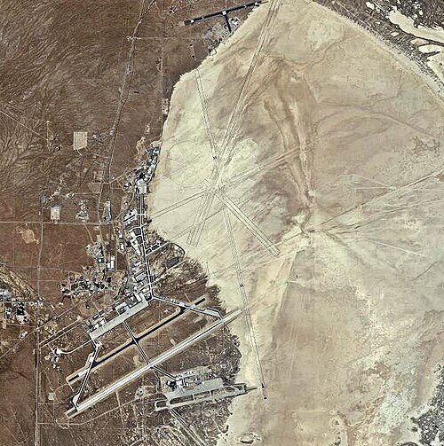
The base exists because of Rogers Dry Lake. [1] In 1932 Lt. Col. Henry “Hap” Arnold began buying land beside what was then Muroc Dry Lake for a bombing range, and from 1935 crews from March Field bombed targets laid out on the desert. [1] Arnold called the lake bed “level as a billiard table”, a natural runway for testing aircraft, and in 1942 America’s first jet, the Bell XP-59 Airacomet, flew from its north shore. [1] On 14 October 1947 Captain Chuck Yeager flew the Bell X-1 past the speed of sound here. [1] The base was renamed in 1949 for Captain Glen Edwards, a test pilot killed in the crash of the Northrop YB-49 flying wing near Muroc in 1948, and the Test Pilot School moved in from Wright Field in 1951. [1] The X-15, the lifting bodies and the first Space Shuttle landings followed, and Edwards stayed the Shuttle’s main landing site until 1991. [1]

Sources
- Edwards Air Force Base. Wikipedia (secondary source). https://en.wikipedia.org/wiki/Edwards_Air_Force_Base (accessed 2026-10-27).
- Airport data: EDW (KEDW), Edwards AFB. Federal Aviation Administration, Aeronautical Information Services, data effective 1–29 October 2026. https://nfdc.faa.gov/nfdcApps/services/ajv5/airportDisplay.jsp?airportId=EDW (accessed 2026-10-27).
- Airport Diagram, Edwards AFB (KEDW). Federal Aviation Administration, digital Terminal Procedures Publication, cycle 2610, 1–29 October 2026. https://aeronav.faa.gov/d-tpp/2610/00500AD.PDF (accessed 2026-10-27).
- Airport Diagram, Edwards/Rogers Lakebed (KEDW). Federal Aviation Administration, digital Terminal Procedures Publication, cycle 2610, 1–29 October 2026. https://aeronav.faa.gov/d-tpp/2610/00500ADROGERSLAKEBED.PDF (accessed 2026-10-27).
- pydcs terrain data: Nevada airports (airports.py). pydcs, an open-source Python library for building DCS World missions, whose terrain data mirrors the game's. https://github.com/pydcs/dcs/blob/5ddcc63a2dcd661e16b14f7aa43219b93044855d/dcs/terrain/nevada/airports.py (accessed 2026-10-27). The Nevada map lists 17 airfields; Edwards is not among them.
- Airport data, KEDW. OurAirports open data (public domain, community-maintained). https://davidmegginson.github.io/ourairports-data/airports.csv (accessed 2026-10-28). Row for KEDW: latitude, longitude and identifiers.
Wikipedia articles are secondary sources and can change; they are cited with the date they were read. FAA airport data and diagrams are official but are reissued every 28 or 56 days; each is cited with the edition read. pydcs mirrors the DCS terrain data at the commit linked.