
Drafted — not technically validated
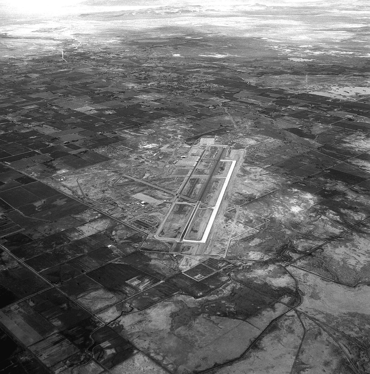
Record revision 1 · The Navy's air combat school in the Nevada desert: home of TOPGUN and of the ranges where carrier air wings train before deploying.
A real-world airfield as described in public sources, and how sim maps represent it. Units, facilities and names change; each is dated where the sources allow, and the charts are not for navigation. Use current official publications for flight planning.
Location and identity
- Country or territory
- United States
- Coordinates
- 39.4166° N, 118.7010° W [5]
- Elevation
- 3,935 ft (1,199 m) [2]
- Identifiers
- ICAO KNFL · FAA NFL
- Other names
- Opened
- 1942; a Naval Auxiliary Air Station until it became a full naval air station on 1 January 1972 [1]
- Theatre
- North America
Role and operators
- Status
- Active · Military
- Roles today
- Weapons and tactics school · Search and rescue
Units
Permanently based units belong to the airfield; rotational and temporarily deployed units are there for a period or an operation. Dates are when the sources place each unit there; "as of" is when a source described it as current.
Current
Naval Aviation Warfighting Development Center: the Navy Fighter Weapons School (TOPGUN), the Carrier Airborne Early Warning Weapons School and the Navy Rotary Wing Weapons School [1]
- Service
- United States, navy
- Basing
- Permanently based
- When
- as of Oct 2026
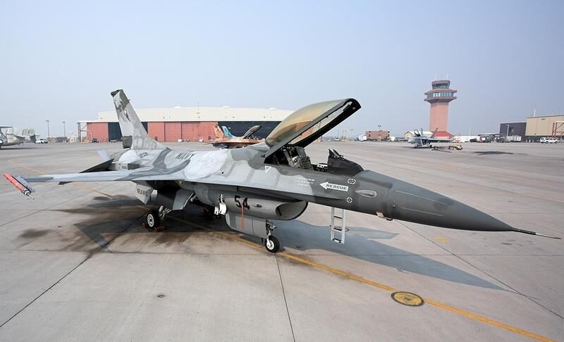
Fighter Squadron Composite 13 (VFC-13), a Navy Reserve adversary squadron [1]
- Service
- United States, navy
- Basing
- Permanently based
- When
- since 1996
Carrier air wings training before they deploy [1]
- Service
- United States, navy
- Basing
- Temporarily deployed
- When
- date not given
Runways and facilities
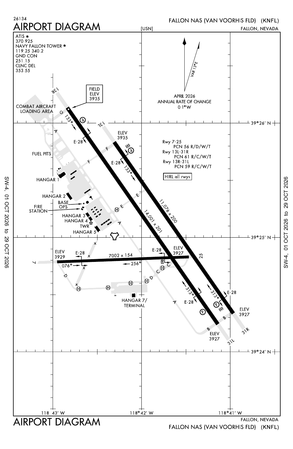
From data effective Oct 2026. Facilities not listed here are not documented in the sources cited, which does not mean the airfield lacks them.
| Runway | Length | Width | Surface |
|---|---|---|---|
| 13R/31L [2] | 14,001 ft (4,268 m) | 201 ft (61 m) | asphalt |
| 13L/31R [2] | 11,076 ft (3,376 m) | 200 ft (61 m) | concrete |
| 07/25 [2] | 7,003 ft (2,135 m) | 152 ft (46 m) | asphalt |
- Arresting gear
- Navaids
- Other
- The Fallon Range Training Complex, some 240,000 acres in the Lahontan and Dixie valleys, with a simulated air defence network of about 20 radar sites [1]
Sim maps
Represented in: no map checked so far
DCS: Nevada Test and Training Range DCS World · Present day
Confirmed absent · checked 2026-10-27 [4]
Only the maps marked represented or confirmed absent have been checked. Any other map may or may not represent this airfield.
Role today
Fallon is the Navy’s main school for air-to-air and air-to-ground combat. [1] It is home to the Naval Aviation Warfighting Development Center, whose schools include the Navy Fighter Weapons School, better known as TOPGUN, and visiting carrier air wingsWing GlossaryJoint terms: 1. An Air Force unit composed normally of one primary mission group and the necessary supporting organizations. 2. A fleet air wing is the basic organizational and administrative unit for naval-, land-, and tender-based… train there before they deploy. [1] The ranges of the Fallon Range Training Complex spread across the Lahontan and Dixie valleys and cover some 240,000 acres; Dixie Valley holds a simulated air defenceAir defense GlossaryJoint terms: Defensive measures designed to destroy attacking enemy aircraft or missiles in the atmosphere, or to nullify or reduce the effectiveness of such attack. network of about 20 radar sites. [1]
History
The airfield was built in 1942 as part of the defences of the West Coast, and the Navy soon took it over for training. [1] Apart from 1946 to 1951, when the Bureau of Indian Affairs used it, it has trained naval aviators ever since. [1] Through the Vietnam War, squadrons rotated through what was then a Naval Auxiliary Air Station before joining their carriers, and on 1 January 1972 the Navy made it a full naval air station. [1] TOPGUN moved here from NAS Miramar in 1996, when Miramar passed to the Marine Corps, and the Naval Strike and Air Warfare Center formed that year from TOPGUN, Strike University and the airborne early warningEarly warning GlossaryJoint terms: Early notification of the launch or approach of unknown weapons or weapons carriers. school TOPDOME. [1] The Navy Reserve adversary squadron VFC-13 came from Miramar at the same time. [1] The field is named Van Voorhis Field for Commander Bruce Van Voorhis (1908–1943), who was awarded the Medal of Honor after his death. [1] The base kept its own search and rescueSAR GlossaryJoint terms: Search and rescue. The use of aircraft, surface craft, submarines, and specialized rescue teams and equipment to search for and rescue distressed persons on land or at sea in a permissive environment. helicopter team from 1972; since 2022 the Navy Rotary Wing Weapons School has taken over the role. [1]

Sources
- Naval Air Station Fallon. Wikipedia (secondary source). https://en.wikipedia.org/wiki/Naval_Air_Station_Fallon (accessed 2026-10-27).
- Airport data: NFL (KNFL), Fallon NAS (Van Voorhis Fld). Federal Aviation Administration, Aeronautical Information Services, data effective 1–29 October 2026. https://nfdc.faa.gov/nfdcApps/services/ajv5/airportDisplay.jsp?airportId=NFL (accessed 2026-10-27).
- Airport Diagram, Fallon NAS (Van Voorhis Fld) (KNFL). Federal Aviation Administration, digital Terminal Procedures Publication, cycle 2610, 1–29 October 2026. https://aeronav.faa.gov/d-tpp/2610/00143AD.PDF (accessed 2026-10-27).
- pydcs terrain data: Nevada airports (airports.py). pydcs, an open-source Python library for building DCS World missions, whose terrain data mirrors the game's. https://github.com/pydcs/dcs/blob/5ddcc63a2dcd661e16b14f7aa43219b93044855d/dcs/terrain/nevada/airports.py (accessed 2026-10-27). The Nevada map lists 17 airfields; Fallon is not among them.
- Airport data, KNFL. OurAirports open data (public domain, community-maintained). https://davidmegginson.github.io/ourairports-data/airports.csv (accessed 2026-10-28). Row for KNFL: latitude, longitude and identifiers.
Wikipedia articles are secondary sources and can change; they are cited with the date they were read. FAA airport data and diagrams are official but are reissued every 28 or 56 days; each is cited with the edition read. pydcs mirrors the DCS terrain data at the commit linked.