Drafted — not technically validated
Record revision 1 · DCS World's free map of Georgia and southern Russia from Anapa to Tbilisi, with 21 airfields.
One simulator's map: what it covers, when it is set, and which airfields in this encyclopedia it represents. Sim maps change with updates; each claim is cited with the date it was read.
DCS: Caucasus
- Simulator
- DCS World
- Made by
- Eagle Dynamics
- Setting
- Present day: The present day, though its makers say it suits realistic and hypothetical operations of any period [1]
- Area
- More than 720 km of the eastern Black Sea coast from Anapa to Tbilisi: southern Russia, the Kuban, the Caucasus Range, western Georgia, Abkhazia and Adjara [1]
- Real-world theatre
- The Caucasus
- Purchase
- DCS WorldDCS: Caucasus Map by Eagle DynamicsFree: comes with the free DCS World downloadDCS World
Store pages checked 2026-10-28. Prices and availability change.
Map
Explore the map or select an airfield. Markers show runway, radio and navigation data. Present-day OpenStreetMap geography; no exact simulator terrain boundary is shown. Airfield markers follow the simulator data, including on historical maps; the basemap does not depict their historical surroundings.
The interactive map is loading. The airfield reference table remains available below.
Airfield overlay: the same versioned simulator data as the table below. © OpenStreetMap contributors · ODbL.
Static overview
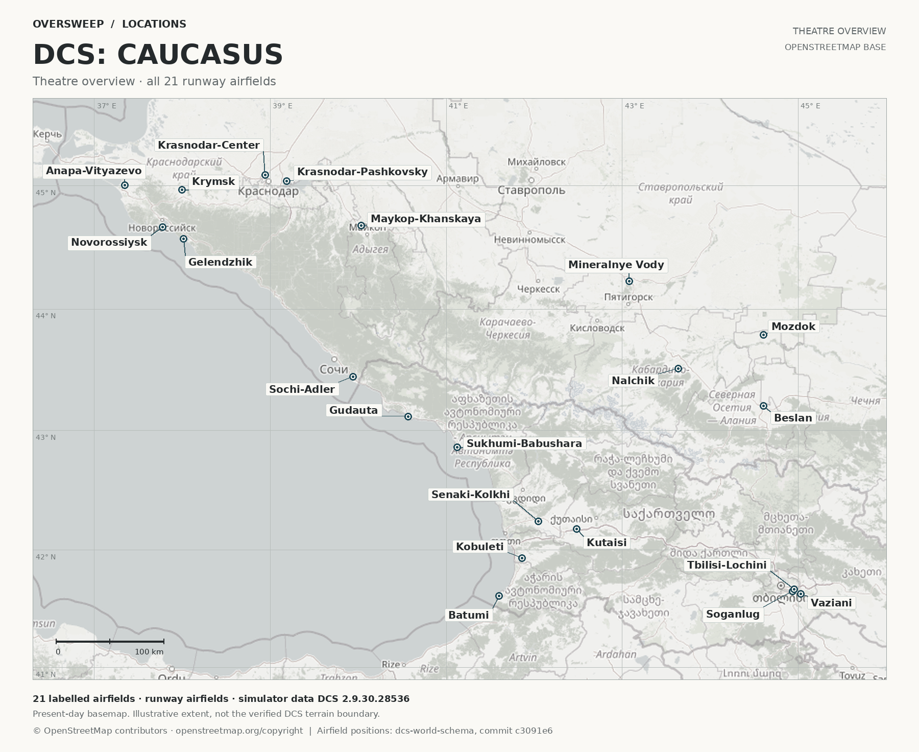
Airfields
Every airfield with a runway in Caucasus's data from the game: 21 airfields. Names link to this encyclopedia's entry where there is one.
| Airfield | Elevation | Runways | Tower (MHz) | TACAN, VOR and NDB | ILS |
|---|---|---|---|---|---|
| Anapa-Vityazevo45.0049° N, 37.3478° E | 141 ft | 22 (217°) / 04 (037°), 8,624 ft | VHF 121.0UHF 250.0low VHF 38.4 · HF 3.75 | — | — |
| Batumi41.6096° N, 41.6002° E | 33 ft | 31 (305°) / 13 (124°), 6,793 ft | VHF 131.0UHF 260.0low VHF 40.4 · HF 4.25 | NDB 430 kHz (LU)TACAN 16X, 977.0 MHz (BTM) | 13: 110.3 (ILU) |
| Beslan43.2057° N, 44.6058° E | 1,722 ft | 10 (094°) / 28 (274°), 9,327 ft | VHF 141.0UHF 270.0low VHF 42.4 · HF 4.75 | — | 10: 110.5 (ICH) |
| Gelendzhik44.5729° N, 38.0116° E | 72 ft | 01 (036°) / 19 (216°), 5,452 ft | VHF 126.0UHF 255.0low VHF 39.4 · HF 4.0 | NDB 1000 kHz (GN)VOR ch 90, 114.3 MHz (GN) | — |
| Gudauta43.1143° N, 40.5697° E | 69 ft | 15 (149°) / 33 (329°), 7,840 ft | VHF 130.0UHF 259.0low VHF 40.2 · HF 4.2 | NDB with marker 395 kHz (XC) | — |
| Kobuleti41.9299° N, 41.8633° E | 59 ft | 25 (249°) / 07 (069°), 7,407 ft | VHF 133.0UHF 262.0low VHF 40.8 · HF 4.35 | TACAN 67X, 1154.0 MHz (KBL) | 07: 111.5 (IKB) |
| Krasnodar-Center45.0869° N, 38.9400° E | 98 ft | 09 (083°) / 27 (263°), 7,659 ft | VHF 122.0UHF 251.0low VHF 38.6 · HF 3.8 | RSBN ch 40 (MB) | PRMG 09: ch 38 (MB) |
| Krasnodar-Pashkovsky45.0380° N, 39.1881° E | 112 ft | 23L (224°) / 05R (044°), 9,739 ft | VHF 128.0UHF 257.0low VHF 39.8 · HF 4.1 | VOR ch 105, 115.8 MHz (KN) | — |
| Krymsk44.9679° N, 37.9950° E | 66 ft | 04 (035°) / 22 (215°), 6,733 ft | VHF 124.0UHF 253.0low VHF 39.0 · HF 3.9 | RSBN ch 28 (KW) | PRMG 04: ch 26 (OX)PRMG 22: ch 26 (KW) |
| Kutaisi42.1776° N, 42.4813° E | 148 ft | 25 (253°) / 07 (073°), 7,936 ft | VHF 134.0UHF 263.0low VHF 41.0 · HF 4.4 | NDB with marker 477 kHz (TI)TACAN 44X, 1005.0 MHz (KTS)VOR ch 83, 113.6 MHz (KT) | 07: 109.75 (IKS) |
| Maykop-Khanskaya44.6813° N, 40.0353° E | 591 ft | 04 (036°) / 22 (216°), 10,196 ft | VHF 125.0UHF 254.0low VHF 39.2 · HF 3.95 | RSBN ch 34 (DG) | PRMG 04: ch 36 (DG) |
| Mineralnye Vody44.2279° N, 43.0812° E | 1,050 ft | 30 (295°) / 12 (115°), 12,316 ft | VHF 135.0UHF 264.0low VHF 41.2 · HF 4.45 | VOR ch 118, 117.1 MHz (MN) | 12: 111.7 (IMD)30: 109.3 (IMW) |
| Mozdok43.7917° N, 44.6058° E | 507 ft | 26 (263°) / 08 (083°), 7,734 ft | VHF 137.0UHF 266.0low VHF 41.6 · HF 4.55 | RSBN ch 20 (MZ) | PRMG 08: ch 22 (MZ)PRMG 26: ch 22 (MK) |
| Nalchik43.5140° N, 43.6365° E | 1,411 ft | 06 (055°) / 24 (235°), 6,721 ft | VHF 136.0UHF 265.0low VHF 41.4 · HF 4.5 | — | 24: 110.5 (INL) |
| Novorossiysk44.6681° N, 37.7783° E | 131 ft | 22 (218°) / 04 (038°), 5,639 ft | VHF 123.0UHF 252.0low VHF 38.8 · HF 3.85 | — | — |
| Senaki-Kolkhi42.2408° N, 42.0480° E | 43 ft | 27 (274°) / 09 (094°), 7,256 ft | VHF 132.0UHF 261.0low VHF 40.6 · HF 4.3 | TACAN 31X, 992.0 MHz (TSK) | 09: 108.9 (ITS) |
| Sochi-Adler43.4444° N, 39.9411° E | 98 ft | 06 (059°) / 24 (239°), 9,687 ft | VHF 127.0UHF 256.0low VHF 39.6 · HF 4.05 | NDB with marker 761 kHz (CO) | 06: 111.1 (ISO) |
| Soganlug41.6495° N, 44.9384° E | 1,483 ft | 32 (313°) / 14 (133°), 7,872 ft | VHF 139.0UHF 268.0low VHF 42.0 · HF 4.65 | — | — |
| Sukhumi-Babushara42.8611° N, 41.1250° E | 43 ft | 30 (295°) / 12 (115°), 11,218 ft | VHF 129.0UHF 258.0low VHF 40.0 · HF 4.15 | — | — |
| Tbilisi-Lochini41.6670° N, 44.9563° E | 1,574 ft | 13R (129°) / 31L (309°), 7,692 ft | VHF 138.0UHF 267.0low VHF 41.8 · HF 4.6 | TACAN 25X, 986.0 MHz (GTB)VOR ch 84, 113.7 MHz (TB) | 13R: 110.3 (IVP)31L: 108.9 (INA) |
| Vaziani41.6290° N, 45.0272° E | 1,524 ft | 13R (137°) / 31L (317°), 7,843 ft | VHF 140.0UHF 269.0low VHF 42.2 · HF 4.7 | TACAN 22X, 983.0 MHz (VAS) | 13R: 108.75 (IVZ)31L: 108.75 (IVI) |
Source: dcs-world-schema reference data: Caucasus airbases, beacons and navaids, dcs-world-schema, open-source data extracted by running DCS World 2.9.30.28536 (extracted 2026-10-04), at commit c3091e6. † Where that data gives an airfield no tower radio, the frequencies come from pydcs terrain data: caucasus airports (airports.py), an open-source library whose terrain data mirrors the game's. Runway headings are magnetic, as the game computes them; lengths and elevations are converted from metres. The game gives TACAN and DME channels no X or Y band. Where a beacon’s listed frequency is the reply or paired VHF frequency of one band (ICAO Annex 10 channel plan), that band is shown. * marks an assumed X: the game lists no frequency that settles it, and every ground TACAN whose frequency does settle it is X. A dash means the game gives none.
Airfield coverage
| Airfield | On this map | Name in the sim | Checked |
|---|---|---|---|
| Batumi International Airport | Represented; 1 known difference | Batumi | 2026-10-28 |
| Ozurgeti Air Base (Kobuleti) | Represented; 1 known difference | Kobuleti | 2026-10-28 |
| Kutaisi International Airport | Represented | Kutaisi | 2026-10-28 |
| Senaki Air Base | Represented; 1 known difference | Senaki-Kolkhi | 2026-10-28 |
| Vaziani Air Base | Represented; 1 known difference | Vaziani | 2026-10-28 |
| Tbilisi International Airport | Represented | Tbilisi-Lochini | 2026-10-28 |
| Gudauta (Bombora) Air Base | Represented | Gudauta | 2026-10-28 |
| Sukhum International Airport (Babushara) | Represented | Sukhumi-Babushara | 2026-10-28 |
| Sochi International Airport | Represented; 1 known difference | Sochi-Adler | 2026-10-28 |
| Anapa (Vityazevo) International Airport | Represented | Anapa-Vityazevo | 2026-10-28 |
| Gelendzhik Airport | Represented | Gelendzhik | 2026-10-28 |
| Krymsk Air Base | Represented | Krymsk | 2026-10-28 |
| Krasnodar Tsentralny | Represented; 1 known difference | Krasnodar-Center | 2026-10-28 |
| Mozdok Air Base | Represented; 1 known difference | Mozdok | 2026-10-28 |
| Vladikavkaz (Beslan) International Airport | Represented; 1 known difference | Beslan | 2026-10-28 |
Each airfield's page cites the sources for its entry. Airfields not listed have not been checked against this map.
Coverage
The Caucasus is DCS World’s free map. It runs for more than 720 km from Anapa to Tbilisi and takes in the Black Sea beaches and subtropics, the Caucasus Range up to Mount Elbrus at 5,600 m, and the steppes and forests to the north. [1] It has 21 airfields, among them the international airports of Sochi-Adler, Mineralnye Vody and Tbilisi-Lochini. [1] The airfield list mixes Russian military fields such as Krymsk, Maykop and Mozdok with Georgian ones such as Senaki-Kolkhi, Kutaisi and Vaziani. [2]
Its makers point to the region’s history, from the Second World War battles in the Kuban and the North Caucasus to the conflicts in Abkhazia and South Ossetia, and say the map suits both realistic and hypothetical operations. [1]
Sources
- DCS: Caucasus Map. Eagle Dynamics (product page). https://www.digitalcombatsimulator.com/en/shop/terrains/caucasus_terrain/ (accessed 2026-10-27).
- pydcs terrain data: Caucasus airports (airports.py). pydcs, an open-source Python library for building DCS World missions, whose terrain data mirrors the game's. https://github.com/pydcs/dcs/blob/5ddcc63a2dcd661e16b14f7aa43219b93044855d/dcs/terrain/caucasus/airports.py (accessed 2026-10-28). 21 airfields: Anapa-Vityazevo, Krasnodar-Center, Novorossiysk, Krymsk, Maykop-Khanskaya, Gelendzhik, Sochi-Adler, Krasnodar-Pashkovsky, Sukhumi-Babushara, Gudauta, Batumi, Senaki-Kolkhi, Kobuleti, Kutaisi, Mineralnye Vody, Nalchik, Mozdok, Tbilisi-Lochini, Soganlug, Vaziani and Beslan.
Wikipedia articles are secondary sources and can change; they are cited with the date they were read. Vendor pages describe the current release of each map.